Local government office nearby Pusat Infrastruktur Data Geospatial Negara
Malaysia
Local government office nearby Pusat Infrastruktur Data Geospatial Negara
Pusat Infrastruktur Data Geospatial Negara
Tingkat 16, Wisma Tanah, Jalan Semarak, Wilayah Persekutuan, Kuala Lumpur Malaysia
contacts phone
:
+60
Latitude:
3.172482
, Longitude:
101.718114
read more
nearest Local government office
180 m
Jabatan Ukur Dan Pemetaan Malaysia
Jalan Sultan Yahya Petra, Kampung Datuk Keramat, Kuala Lumpur
Local government office
read more
670 m
Job Malaysia
32, Jalan Gurney, Kampung Datuk Keramat, Kuala Lumpur
Local government office
read more
847 m
MPOU
Kementah, Kuala Lumpur
Local government office
read more
1.305 km
KWAP, Level 39, Integra Tower
Jalan Tun Razak, Kampung Datuk Keramat, Kuala Lumpur
Local government office
read more
1.382 km
Intangible Sdn Bhd
Menara Citibank, 165, Jalan Ampang, Kuala Lumpur
Local government office
read more
1.903 km
Yayasan Wilayah Persekutuan
Jalan Raja Abdullah, Kampung Baru, Kuala Lumpur
Local government office
read more
1.94 km
The Perinatal Society of Malaysia
2-7, Medical Academies of Malaysia, 210, Jalan Tun Razak, Titiwangsa, Kuala Lumpur
Local government office
read more
1.978 km
Malaysia Visa Center
Menara Ta One, Level-8.03, 22, Jalan P Ramlee, Kuala Lumpur
Local government office
read more
2.085 km
Kesatuan Kebangsaan Pekerja Pekerja Penguasa Penguasa Tempatan Semenanjung Malaysia
Wisma ANULAE, No. 74-2, Jalan Raja Bot, Wilayah Persekutuan, Kuala Lumpur
Local government office
read more
2.138 km
Setiausaha Agung National Union of Hotel, Bar & Restaurant Workers, Peninsula Malaysia
No. 44-4 C, Jalan Sultan Ismail, Wilayah Persekutuan, Kuala Lumpur
Local government office
read more
2.167 km
Pejabat Kesihatan Titiwangsa
Jalan Raja Abdullah, Kampung Baru, Kuala Lumpur
Local government office
read more
2.3 km
United Zone
1, Jalan Lumut, Titiwangsa Sentral, Kuala Lumpur
Local government office
read more
2.343 km
DBKL Tower 3 Bandar Wawasan
Jalan Raja Abdullah, Bandar Wawasan, Kuala Lumpur
Local government office
read more
2.605 km
KOPERASI SURIA MALAYSIA BERHAD
Tingkat 4, Menara Manicavasagam, No. 1, Jalan Rahmat, 50350 Kuala Lumpur, Wilayah Perseketuan., No. 1, Jalan Rahmat Off Jalan Ipoh, Kuala Lumpur
Local government office
read more
2.691 km
BLS International, Indian Passport And Consular Services
326, Jalan Tuanku Abdul Rahman, Chow Kit, Kuala Lumpur
Local government office
read more
2.772 km
Pension Worries
29-01, 203 Jalan Bukit Bintang, Kuala Lumpur
Local government office
read more
2.8 km
TenderDirect (M) Sdn Bhd
Plaza Permata, 6 Jalan Kampar, Lumpur, WP Kuala Lumpur, Kuala Lumpur
Local government office
read more
2.867 km
Nation Drive Wilayah Sdn Bhd
716-1, Jalan Sentul, Sentul, Kuala Lumpur
Local government office
read more
2.981 km
National Tourism Council Malaysia
Box 275, Lot B3, Tingkat 3, KL Plaza, Jalan Bukit Bintang, Bukit Bintang, Wilayah Persekutuan, Kuala Lumpur
Local government office
read more
3.307 km
Setiausaha Agung E.P.F. Board Staff Union
Bangunan KWSP, Tingkat 12, Jalan Raja Laut, Wilayah Persekutuan, Kuala Lumpur
Local government office
read more
3.524 km
Enviroaire Sdn Bhd
35 - 2, Jalan 3/76d, Desa Pandan, Kuala Lumpur
Local government office
read more
3.534 km
UTC Kuala Lumpur
PUDU SENTRAL, UTC - Urban Transformation Centre Bangunan UTC 55100 Malaysia, Kuala Lumpur
Local government office
read more
3.551 km
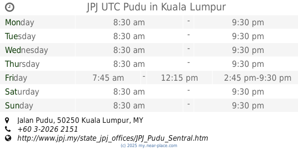
JPJ UTC Pudu
PUDU SENTRAL, T2-5, Jalan Pudu, City Centre, Kuala Lumpur
Local government office
read more
3.595 km
Ministry of Tourism and Culture Malaysia (Kementerian Pelancongan dan Kebudayaan Malaysia)
Kuala Lumpur City Centre, Kuala Lumpur
Local government office
read more
3.649 km
Perumahan Awam Seri Kelantan Blok B
Sentul Pasar, Kuala Lumpur
Local government office
read more
📑
all categories
Accounting
Administrative area level 1
Administrative area level 2
Airport
Amusement park
Aquarium
Art gallery
Atm
Bakery
Bank
Bar
Beauty salon
Bicycle store
Book store
Bowling alley
Bus station
Cafe
Campground
Car dealer
Car rental
Car repair
Car wash
Casino
Cemetery
Church
City hall
Clothing store
Colloquial area
Convenience store
Courthouse
Dentist
Department store
Doctor
Electrician
Electronics store
Embassy
Establishment
Finance
Fire station
Florist
Food
Funeral home
Furniture store
Gas station
General contractor
Grocery or supermarket
Gym
Hair care
Hardware store
Health
Hindu Temple
Home goods store
Hospital
Insurance agency
Jewelry store
Laundry
Lawyer
Library
Light rail station
Liquor store
Local government office
Locality
Locksmith
Lodging
Meal delivery
Meal takeaway
Mosque
Movie rental
Movie theater
Moving company
Museum
Natural feature
Neighborhood
Night club
Painter
Park
Parking
Pet store
Pharmacy
Physiotherapist
Place of worship
Plumber
Point of interest
Police
Political
Post office
Premise
Real estate agency
Restaurant
Roofing contractor
Route
Rv park, camping
School
Shoe store
Shopping mall
Spa
Stadium
Storage
Store
Sublocality
Subpremise
Subway station
Supermarket
Taxi stand
Train station
Transit station
Travel agency
University
Veterinary care
Zoo
administrative area level 3
administrative area level 4
sublocality level 1
↑